
STE Blog
Discover updates, research applications, and performance insights from STE’s continuous evolution in hydraulic and sediment modeling.
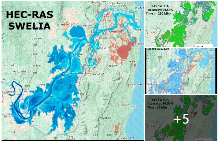
HEC-RAS vs STE — Accuracy & Speed Challenge!
🌊 Flood Simulation Accuracy Assessment – Yamba, Australia Flood (March 2022)How fast can we simulate a real flood without losing accuracy?To find out, I investigated the Yamba flood event (NSW, Australia, February–March 2022) to evaluate the accuracy and efficiency of fast flood simulation modules in STE compared with HEC-RAS and…
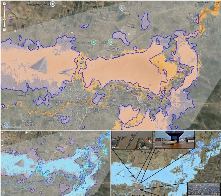
🌊 Real-Time Flood Mapping in STE 🌊
Today I tested the newest improvements in the Real-Time Flood Mapper tool inside STE by simulating the devastating 2019 Golestan flood in Aq Qala, Iran.This flood was extremely challenging to model, even for advanced hydrodynamic solvers (SWE), due to:◾ Very mild to even negative slopes near the Caspian Sea◾ Lack…

Locate MyPictures tool in STEGIS
Ever gone on a field visit, snapped a bunch of photos, and later couldn’t remember exactly where each one was taken? Or captured floodplain shots and couldn’t pinpoint which part of the river they belong to?Meet the Locate MyPictures tool in STEGIS. 📸🗺️Drop in your geotagged images and STEGIS instantly…

Elevation Harmonizer
“Ever tried merging two DEM rasters — like SRTM with a high-resolution survey DEM — and ended up with those annoying steps or edges at the boundary? 😫”That problem stops your flood modeling from being accurate.👉 In STE, I built Elevation Harmonizer tool that fixes this. Elevation Harmonizer Tool You…

From 2D physics to immersive 3D visualization — all inside STE, STEGIS, and STEGeo3D
This 2D simulation perfectly captures a hydraulic jump as supercritical flow rushes down the slope and transitions abruptly to subcritical flow. The sudden rise in water depth and the turbulent standing waves mark the energy dissipation zone — a classic feature of open channel hydraulics.The multiple visible wave crests are…

🔥 New in STE: Real-Time Flood Inundation Mapper ⚡
I’m thrilled to announce a powerful new feature coming to the next version of STE — the Real-Time Flood Inundation Mapper — along with an advanced post-processing module that delivers more than just flood depth maps.🔧 Using novel and computationally efficient 1D/2D methods, the Real-Time Inundation Mapper creates flood inundation…