


Streamlined Sediment and Flood Modeling
STE is a sophisticated software solution designed to model sediment transport and flood dynamics with precision. By integrating advanced modeling capabilities, an intuitive interface, fast simulations, and seamless GIS integration, STE enables professionals and researchers to perform accurate and efficient analyses. Whether you are assessing flood risks, managing sediment transport, or conducting hydrological studies, STE is built to improve the speed, ease, and accuracy of your work.
Core Features of STE
STE combines intuitive design, ensuring effortless data input and user-friendly operation. With advanced algorithms, it delivers precise results every time, all while dramatically speeding up simulations for faster, more efficient analysis.

Sediment Transport Modeling
STE offers comprehensive sediment estimation capabilities, utilizing 92 hydraulic sediment transport formulas for bed load, suspended load, and total load. It also supports sediment load estimation using hydrologic methods, providing accurate results for diverse river systems.

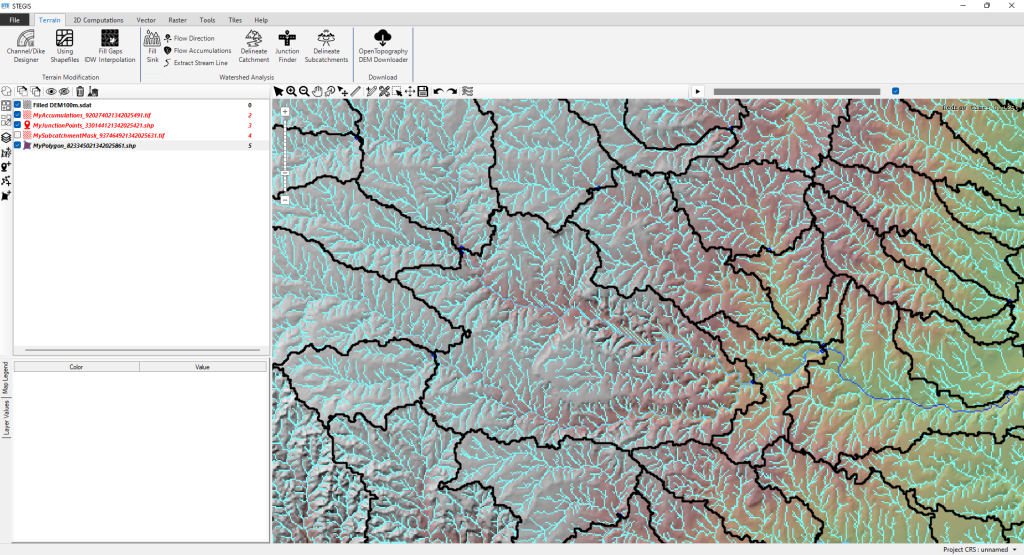
STEGIS
STEGIS streamlines GIS operations for terrain modification, flood and sediment modeling. With STEGIS, users can easily analyze and prepare data like topography and landcover for simulations. STEGIS also supports hydrological analysis, water accumulations, and watershed delineation, offering a complete solution for modeling.

Real-Time Flood Modeling
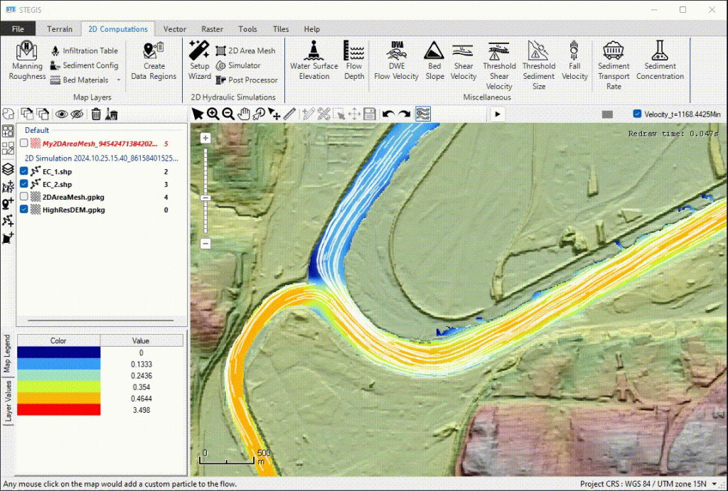
STE simplifies 2D flood and sediment modeling, ensuring effortless operation without compromising accuracy. With advanced algorithms, STE delivers lightning-fast flood simulations on CPU, while results are easily analyzed in STEGIS.
STE Is Open to the Community
STE is available through Community and Professional plans.
Your support helps us maintain global infrastructure, accelerate development, and keep STE evolving:
Completing User Documentation
Making sure STE is fully documented to help users navigate all features confidently.
Developing New Features
Continuously expanding STE with powerful capabilities, bringing cutting-edge hydrology and sediment modeling tools into your hands.
Creating Tutorials
Producing step-by-step tutorials and videos to help users get the most out of STE without barriers.
Roadmap
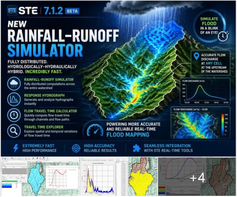
💥 STE 7.1.2 Beta is out!
💥 STE 7.1.2 Beta is out! This version introduces major improvements across performance, hydrology, and analysis—bringing STE one step closer to a fully integrated hydro–hydraulic modeling environment. 🌧 Hydrology & Analysis — A Major Leap Forward This update introduces a new generation of hydrology tools designed to directly support real-time…
📣 STE v7.1.1 Released — New Capabilities & Next Steps
We’re happy to announce the release of STE v7.1.1, bringing a wide range of performance improvements, new algorithms, and expanded analysis tools across 1D, 2D, and GIS workflows.🔧 Key Improvements & New Features in v7.1.1This release focuses on speed, robustness, and deeper hydraulic diagnostics:• Faster Genetic Algorithm performance• New junction-finder…
Happy New Year! 🥳
As water scouring washes away 2025 in this STE simulation, 2026 emerges downstream reminding us that progress is driven by movement, change, and forward momentum. Onward into 2026. 🌊
Storm Designer: From Rainfall Data to Flood Simulation in Minutes!
I’m excited to unveil Storm Designer – our latest tool in STE that revolutionizes how we approach flood risk assessment!What is Storm Designer?A powerful module that transforms historical precipitation data into actionable flood modeling inputs. Simply put: it creates design storm hyetographs based on IDF (Intensity-Duration-Frequency) curves for any return…
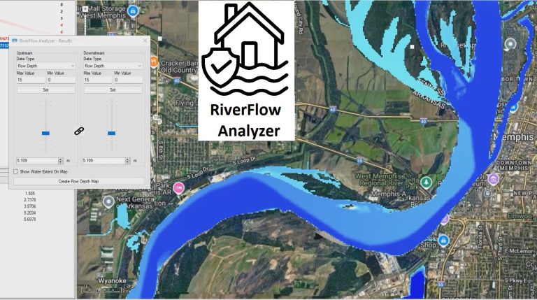
Find the Safe Flow in rivers and estimate inundation extents effortlessly! 💡
How? Let me introduce RiverFlow Analyzer in STE.With RiverFlow Analyzer, you simply select a reach of the river — then adjust upstream and downstream flow discharge or water surface elevation using intuitive sliders.As you tune the system, the inundation extent and flow depth update instantly on the map, giving you…
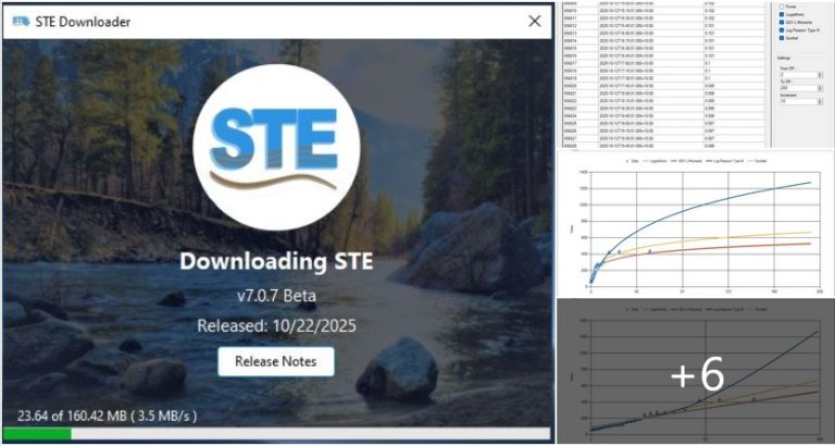
The STE 7.0.7 is Here! Smarter, Faster, and More Capable Than Ever!
I’m excited to announce the release of the latest version of STE, packed with tools that make flood and sediment modeling even more powerful and effortless.Here’s what’s new 👇⚙️ STE DownloaderDownloading STE is now fully automated.With STE Downloader, users can download and install the latest version directly within the software….
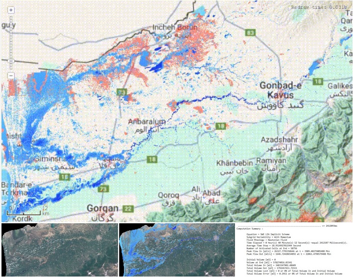
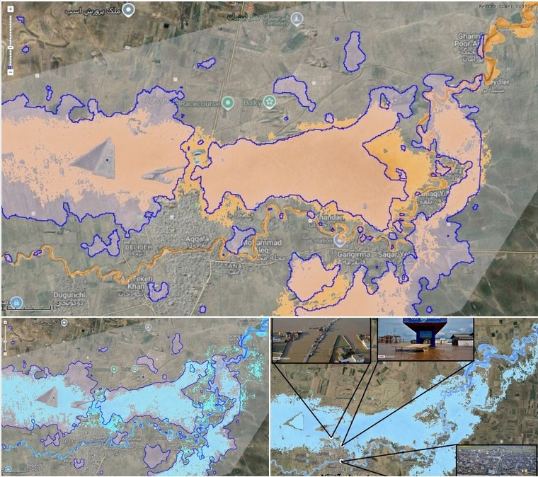
🌧️ Fast Full Pluvial (Rain-on-Grid) Simulation with STE – The 2019 Golestan Flood
One of the biggest challenges in flood modeling is predicting inundation caused by high-intensity precipitation — when rainfall itself drives the flood.To test STE’s rain-on-grid simulation capabilities, I modeled the March–April 2019 Golestan Flood (Iran) — a devastating event where intense rainfall over the upstream catchments and the province itself…
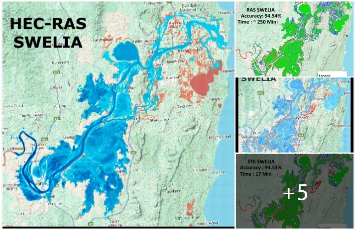
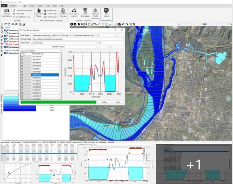
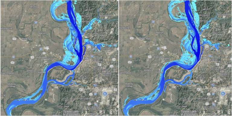
HEC-RAS vs STE — Accuracy & Speed Challenge!
🌊 Flood Simulation Accuracy Assessment – Yamba, Australia Flood (March 2022)How fast can we simulate a real flood without losing accuracy?To find out, I investigated the Yamba flood event (NSW, Australia, February–March 2022) to evaluate the accuracy and efficiency of fast flood simulation modules in STE compared with HEC-RAS and…
🌊 Real-Time Flood Mapping in STE 🌊
Today I tested the newest improvements in the Real-Time Flood Mapper tool inside STE by simulating the devastating 2019 Golestan flood in Aq Qala, Iran.This flood was extremely challenging to model, even for advanced hydrodynamic solvers (SWE), due to:◾ Very mild to even negative slopes near the Caspian Sea◾ Lack…
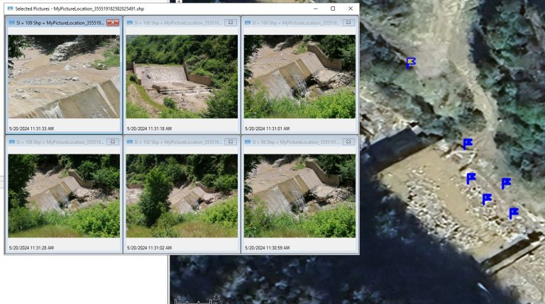
Locate MyPictures tool in STEGIS
Ever gone on a field visit, snapped a bunch of photos, and later couldn’t remember exactly where each one was taken? Or captured floodplain shots and couldn’t pinpoint which part of the river they belong to?Meet the Locate MyPictures tool in STEGIS. 📸🗺️Drop in your geotagged images and STEGIS instantly…
Elevation Harmonizer
“Ever tried merging two DEM rasters — like SRTM with a high-resolution survey DEM — and ended up with those annoying steps or edges at the boundary? 😫”That problem stops your flood modeling from being accurate.👉 In STE, I built Elevation Harmonizer tool that fixes this. Elevation Harmonizer Tool You…
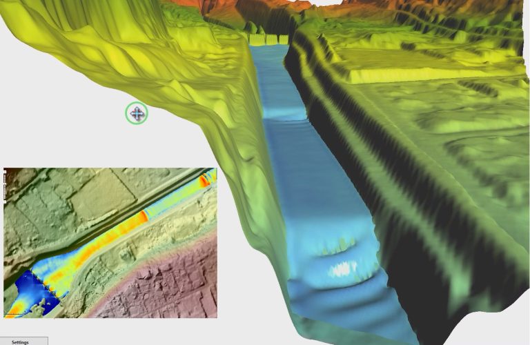
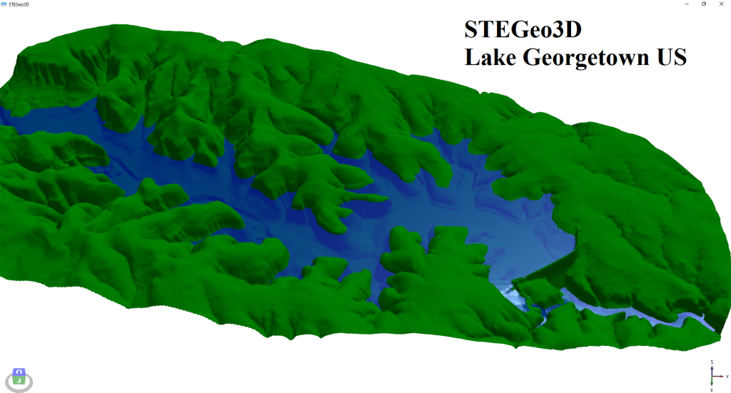
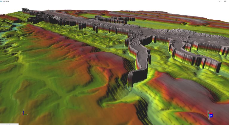
From 2D physics to immersive 3D visualization — all inside STE, STEGIS, and STEGeo3D
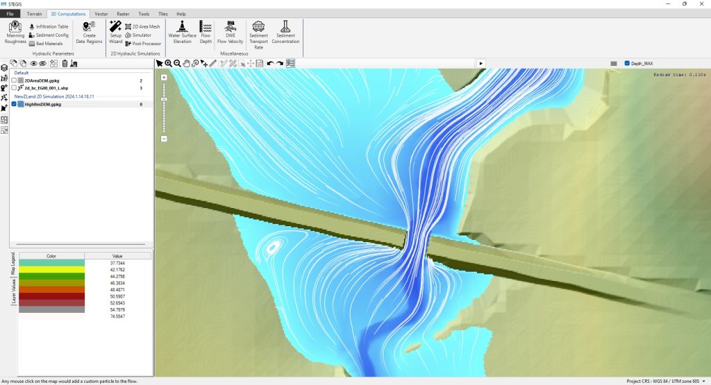
This 2D simulation perfectly captures a hydraulic jump as supercritical flow rushes down the slope and transitions abruptly to subcritical flow. The sudden rise in water depth and the turbulent standing waves mark the energy dissipation zone — a classic feature of open channel hydraulics.The multiple visible wave crests are…
🔥 New in STE: Real-Time Flood Inundation Mapper ⚡
I’m thrilled to announce a powerful new feature coming to the next version of STE — the Real-Time Flood Inundation Mapper — along with an advanced post-processing module that delivers more than just flood depth maps.🔧 Using novel and computationally efficient 1D/2D methods, the Real-Time Inundation Mapper creates flood inundation…
Bedform Evolution in Action!
Watch ripples and dunes dynamically form in this 2D movable bed simulation using STE’s Sediment Module. These results highlight how STE captures both small-scale ripples and large-scale dunes, offering a powerful and physically realistic sediment transport modeling experience.🌊 Coupled morphodynamics⚙️ Real-time 3D visualization🧠 Physically-based sediment processesWe’re proud to share these…
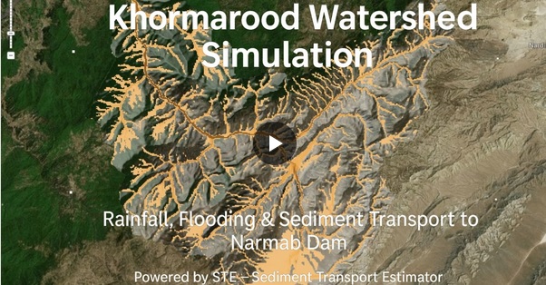
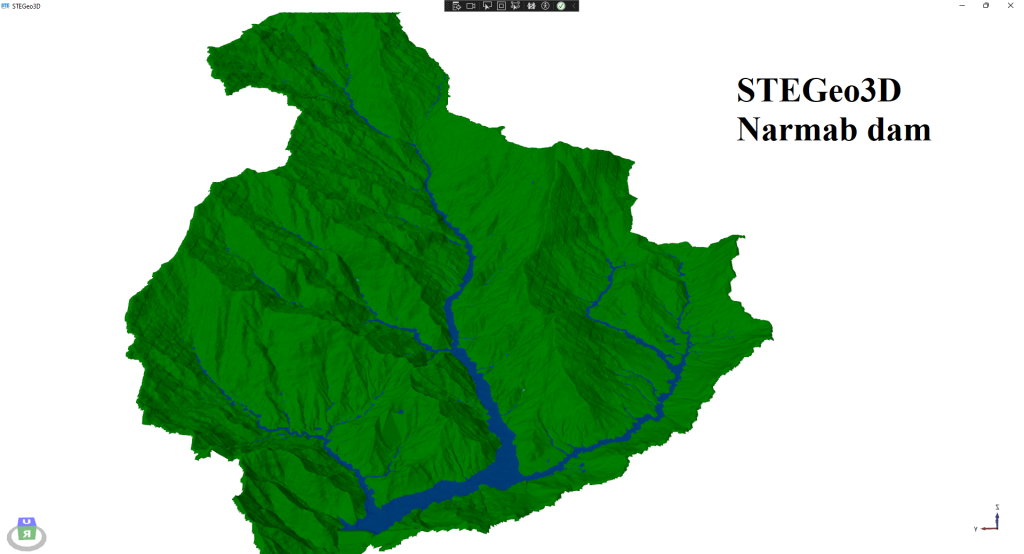
🌧️ How Much Sediment Does a Flood Bring?
In this video, we use STE to simulate rainfall, flooding, and sediment movement across the Khormarood watershed. The results show how much sediment is eroded from upstream and transported downstream—eventually threatening infrastructure like the Narmab Dam.💡 This work is part of a research project focused on finding practical solutions to…
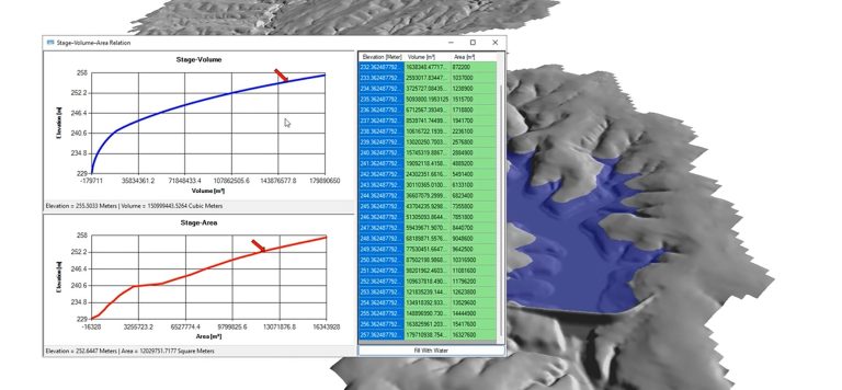
New Tool Added to STEGIS: Extract Stage–Area–Volume Relation
I’ve just completed a brand-new tool in STEGIS that allows users to extract Elevation–Area and Elevation–Volume relationships for dam storage using a simple polygon drawn on the DEM. 📐🌊But I didn’t stop there.To help visualize how the reservoir behaves at different water levels, I’ve also added a powerful feature that…