
Features
This software is composed of several integrated modules, all designed with the goal of simplifying complex computations and significantly accelerating the process of achieving accurate results.
Hydraulic and Sediment Analysis in River Cross-Sections and Hydrometric Stations, with Identification of the Most Suitable Sediment Load Estimation Methods (STE)
This section of the software has been developed to facilitate the study and comparison of various sediment load estimation methods in river cross-sections and hydrometric stations. This software is capable of estimating sediment load using two approaches:

Hydraulic Calculation Features in STE
The hydraulic sediment transport module in STE provides users with the following advanced capabilities:
✅ Sediment Data Analysis & Particle Size Computation
✅ River Cross-Section Analysis & Computation of All Related Parameters
✅ Energy Slope Calculation Using Various Models
✅ Flow Discharge Estimation & Stage-Discharge Curve Development Using:
- Average Velocity Estimation Models
-Coherence
-Manning (SCM-DCM)
-Engelund and Hansen
-Van Rijn
-Haidera and Valentine
-Einstein and Barbarossa - Lateral Velocity Distribution Models
-Shiono & Knight Model – SKM
✅ Optimization of SKM Parameters Using Measured Data & Genetic Algorithm (GA)
✅ Regression Line Fitting & Artificial Neural Network (ANN) Training for More Accurate Flow Estimation
Sediment Load Estimation
✅ Bed Load Discharge Estimation Using 56 Sediment Transport Formulas
✅ Suspended Load Discharge Estimation Using 15 Sediment Transport Formulas
✅ Total Load Discharge Estimation Using 22 Sediment Transport Formulas
Additional Hydraulic Features
✅ Equipped with 17 Different Methods for Shear Stress Estimation at the Riverbed
✅ Equipped with 39 Methods for Determining Threshold of Sediment Motion for Uniform Sediments & 6 Methods for Non-Uniform Sediments
✅ Equipped with 22 Different Methods for Fall Velocity Calculation
✅ Utilizes Genetic Algorithm to Find the Best Combination of Models for Enhancing Calculation Accuracy
✅ Estimating Lateral Sediment Load Distribution
✅ Computational Error Assessment, with Reports on Each Method & Recommendation of the Best Method for the Rivers
Accuracy Enhancement in Sediment Load Estimation Using:
1️⃣ Calibration Coefficients
2️⃣ Merging Sediment Transport Formulas to Develop a More Accurate Method
3️⃣ Equation Refinement & Modification
4️⃣ Training Artificial Neural Networks (ANNs) to Estimate Average Sediment Load and Lateral Distribution

-Hydrologic methods (Click Here…)

Hydrological calculations rely on previous river studies and are generally less accurate than hydraulic methods. However, they require fewer and simpler input parameters, such as flow discharge and occurrence time, making them a practical choice when detailed hydraulic data is unavailable.
The hydrological calculations module in STE offers the following features:
- Unlimited data entry for each project file.
- Flexible data filtering by river name, cross-section, year, month, day, and more.
- Advanced data filtering techniques to enhance regression line fitting and artificial neural network (ANN) training.
- Outlier detection and removal for improved analysis accuracy.
- Regression line fitting using:
- Single-line sediment rating curves (USBR) with correction coefficient support with models such as FAO, QMLE, Smearing, Beta, and MVUE.
- Multi-line sediment rating curves (S-curves)
- Smart data classification using a genetic algorithm to optimize standard deviation reduction (SDR).
- Artificial Neural Network (ANN) training for sediment load prediction.
- Sediment load estimation via sediment rating curves and trained ANNs for enhanced accuracy.
This module provides users with powerful data analysis tools to improve hydrological sediment transport estimations efficiently and effectively.

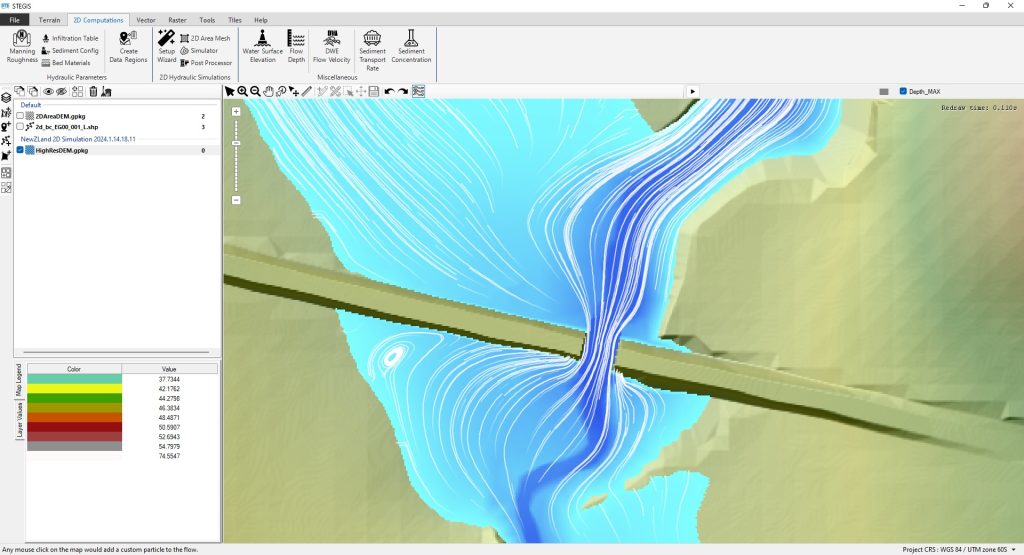
Sediment Transport Estimation in Geographic Information System (STEGIS)
This module of the software is specifically developed for performing 2D simulations and offers a wide range of GIS operations for users. STEGIS can be considered an independent Geographic Information System (GIS) tailored for hydrological and hydraulic analyses. In addition to performing calculations, STEGIS provides powerful tools for preparing and managing inputs for 2D models, visualizing and analyzing results, and streamlining the entire modeling workflow. (Click Here…)
The STEGIS plugin is responsible for performing geographical analyses, executing all GIS operations, and conducting 2D computations, while providing and analyzing results. During the development of this plugin, efforts have been made to code and include all the tools required by users so that they do not need to exit the software environment when conducting modeling and performing hydraulic, hydrological, and other analyses. Therefore, the plugin ensures that all necessary tools for working with raster, vector, and geographical files, as well as performing hydraulic, hydrological, and topographical computations and analyses, are readily available and user-friendly.
In designing the user interface of this section of the software, efforts have been made to categorize all tools based on their functionality and make them easily accessible to create a user-friendly environment. This ensures that working with the plugin is as simple and straightforward as possible. All data, maps, and files generated by this plugin can be saved either permanently or temporarily and can be easily retrieved.
The main interface of this plugin consists of eight distinct sections, including:
- Map
- Main Layers
- Time-Series Layers
- Map Tools
- Layer Tools
- Tiles
- Coordinate Reference System (CRS)
- Computation and Modeling Tools
STEGeo3D
STEGeo3D is a 3D visualization tool within STE that renders Digital Elevation Models (DEM) in 3D and overlays the water surface elevation to provide an intuitive way to analyze flood simulations and terrain data. STEGeo3D helps users visually analyze simulation results, making it easier to interpret flood behavior and topographic changes. (Click Here…)
Sediment Transport Estimation in Data Laboratory (STELAB)
STELAB is a powerful and versatile data mining and modeling system designed to assist users in analyzing complex datasets, developing predictive models, and optimizing computational processes. Originally developed as IM4STE, this module has evolved into an intelligent toolset capable of handling diverse analytical tasks across multiple domains. (Click Here…)
In today’s data-driven world, vast amounts of information are collected across various fields, from engineering and environmental sciences to finance and healthcare. However, raw data alone holds little value unless meaningful patterns and insights can be extracted. Data mining plays a crucial role in this process, enabling users to analyze large datasets, identify trends, and develop predictive models.
Modern data mining techniques, such as regression analysis, artificial neural networks (ANNs), and optimization algorithms, help improve decision-making and enhance the accuracy of computational models. Whether applied to engineering, scientific research, or business intelligence, these techniques empower users to discover relationships, optimize processes, and forecast outcomes with greater precision.
Key Features of STELAB:
- Regression Analysis: Identifies and quantifies relationships between variables to improve data-driven estimations.
- Artificial Neural Networks (ANNs): Trains machine learning models to predict outcomes and recognize patterns.
- Data Filtering & Outlier Detection: Enhances dataset quality by removing noise and improving accuracy.
- GA Fitting and Training System: Uses Genetic Algorithms (GA) to optimize model parameters and improve predictive performance.
By integrating STELAB into various workflows, users can extract meaningful insights, enhance model accuracy, and automate complex analytical processes. Whether applied to engineering, environmental modeling, economics, or beyond, STELAB provides a robust and intelligent solution for advanced data analysis and predictive modeling.